


Canadian Buoyage System
In 1983, Canada adopted the IMO (International Maritime Organization) Buoyage System, or aids to navigation, used internationally. This system includes port hand buoys, starboard hand buoys, cardinal buoys and special buoys.
Aids to Navigationh
Aids to navigation are devices (buoys) or systems (collision regulations), that are external to the pleasure craft. They are provided to help the operator of a pleasure craft determine position and course. They can additionally warn the operator of dangers or obstructions and advise the operator of the location of the best or preferred route.
Port Hand and Starboard Hand Buoys
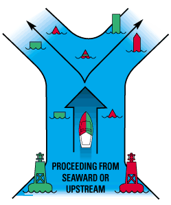
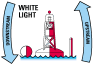
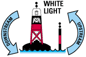
Port hand buoys are green and starboard hand buoys are red. They show which side of a channel is safest to travel; accordingly, they mark channels or hazards. Generally, green buoys must be passed on the left side of a craft heading upstream, i.e., against the current. Red buoys must be kept on the right side of a craft when proceeding in the upstream direction. A simple rule is red to the right when returning, or the three Rs: red, right, return.
In many places, the direction of the current is determined by consensus or by the tide. It is important to be thoroughly familiar with the aids to navigation in your region.
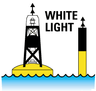
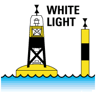
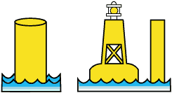
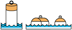
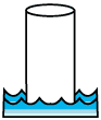
Port Hand BuoysGreen in colour. They can be shaped as:
If they do not have a green light they will be flat on top |
 |
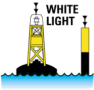
Starboard Hand BuoysRed in colour. They can be shaped as:
If they do not have a red light they will be conical on top. |
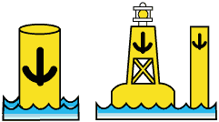
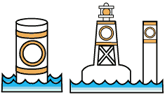
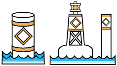
Green port hand buoys
- marks the port (left) side of a channel or the location of a danger and must be kept on the port (left) side of a pleasure craft when proceeding in the upstream direction;
- it is coloured green;
- displays identification letter(s) and odd number(s);
- if it carries a topmark, the topmark is a single green cylinder;
- if it carries a light, the light is green and is a flashing (FI) 4 s or quick flashing (Q) 1 s;
- if the buoy does not carry a light, it has a flat top.
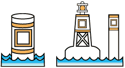
Red starboard hand buoys
- Marks the starboard (right) side of a channel or the location of a danger and must be kep on the starboard (right) side of a pleasure craft when proceeding in the upstream direction;
- is coloured red;
- displays identification letter(s) and even number(s);
- if it carries a topmark, the topmark is a single red cone, pointing upward;
- if it carries a light, the light is red and is a flashing (F1) 4 s or quick flashing (Q) 1 s;
- if the buoy does not carry a light, it has a pointed top.
A port hand day beacon:
|
A starboard hand day beacon:
|
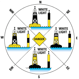
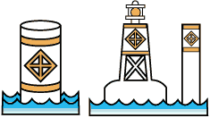
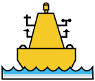
Cardinal Buoys
There are four types of cardinal buoys: north, south, west and east. Cardinal buoys are used to indicate the direction of the safest waters. A north cardinal buoy indicates that the deepest or safest water exists to the north of the buoy. The vessel must travel north past the north buoy; in this way, the buoy is between the hazard and the craft. The same principles apply to all of the cardinal buoys. For more details on the hazard indicated by the buoy, a nautical chart must be consulted; the buoyage system is therefore used in tandem with nautical charts.
There are two ways to distinguish among cardinal buoys: by colour and by the shape of their conical topmarks. The direction of the point indicates the type of cardinal buoy. Accordingly, the cones on a north cardinal buoy point north, and on a south cardinal buoy, point south.
 |
North Cardinal Buoy
|
 |
South Cardinal Buoy
|
 |
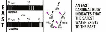
East Cardinal Buoy
|
 |
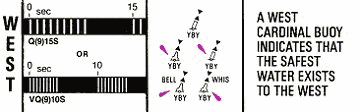
West Cardinal Buoy
|
As with any buoy ... when encountered you should refer to your Nautical Charts for specific information.
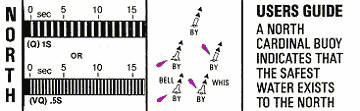
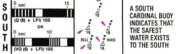
Light Characteristics of Cardinal Buoys
The lights on all cardinal buoys will be white in colour, (if the buoy is so equipped). In order to identify these buoys in darkness or reduced visibility, each one can be distinguished by different light flash characteristics.
The flash characteristics are based on the same numbering principle as an ordinary time clock.
The number of flashes coincides with the position of the face of the clock.
|
North buoys flash at the rate of 1 per second or 60 per minute. A very quick flash can also be used 10 flashes every 5 seconds.
|
||
|
West buoys flash at the rate of 9 times in 15 seconds. A very quick flash can also be used 9 flashes every 10 seconds. |
 |
East buoys flash at the rate of 3 times every 10 seconds. A very quick flash can also be used 3 flashes every 5 seconds |
|
South buoys flash at the rate of 6 times in 15 seconds
followed by a single long flash. A very quick flash can also be used 6
flashes every 10 seconds plus 1 longer flash at the end of each group to
mark the end of 1 flash cycle.
|
 |
|
Anchorage Buoy
Mooring Buoy |
 |
 |
|
Control Buoy
Hazard Buoy |
 |
 |
|
Information Buoy
Swimming Buoy |
 |
 |
|
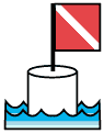
Diving Buoy
Keep Out Buoy |
 |
 |
|
Scientific Buoys (O.D.A.S.)
Fairway Buoy |
 |
 |
|
Isolated Danger Buoy
|
 |
In addition to the above mentioned special buoys, you could also encounter posted command signs or warning signs. These can be used to relay a host of information or provide warnings of impending danger. Some of these are:
- no wake zones
- no anchorage area signs
- speed limit zone signs
- low head dam hazard signs
- overhead or underwater power line hazard signs
- pipe line hazards signs
It cannot be stressed enough that every time you encounter a sign or buoy you should reference your nautical charts to ensure that you correctly interpret the information.
The Nautical Chart
The Different Types of Chart
A simple visit to a map store will quickly convince you of the vast range of products available. Outdoor enthusiasts can find topographical maps for mountain excursions, or guide maps to lakes and rivers to plan their canoe expeditions.
Naturally, travelers can plan their trips with a land, tourist or road map, and farmers can see the boundaries of their fields on a farm map. For boaters, the nautical chart is vital tool.
Main Features of a Nautical Chart
Nautical charts provide information on waterways. They give useful information to boaters, especially on water depth, the type of bottom, the type of shoreline, current direction, coastal altitude, easily identifiable landmarks and aids to navigation.
The Canadian Hydrographic Service publishes all nautical charts. For pleasure craft, large scale maps (i.e., covering a small portion of the region) are often the most useful because of all the detail they contain.
To know which regional chart is most appropriate for your activity, consult the Nautical Chart Catalogue. This catalogue is a large map showing the area covered by each available chart. For information on how to obtain charts, contact the Canadian Hydrographic Service.
Importance of the Nautical Chart to Boaters
Charts provide a host of information to boaters that only detailed knowledge and experience of the waterway could replace.
Using a nautical chart makes the boaters task in a rescue situation easier in many ways. It:
- identifies a launch site
- shows the best route in light of currents, rapids, obstacles, etc.
- shows the location of waterway
- allows for an assessment of distances
- shows location on the water.
On receiving a distress call, the time may not seem right to carefully study a nautical chart. However, if the chart is available, the knowledge gained could mean the difference between locating and successfully helping out at a water accident or a tragedy.
Topographical maps are maps of the land areas depicting natural and artificial features of the land, including elevation contours, shoreline, rocks, land features above water, and cultural features:
- They are intended primarily for the use of the general public on the land;
- They are published by Natural Resources Canada and some provincial authorities;
- 3 They are sometimes used when navigational maps (charts) are not available, but they usually do not depict: underwater hazards, marine aids to navigation, channels, anchorage areas etc.
Other Navigation Aids
A magnetic compass can be used to help the operator of a pleasure craft find directions. It must be remembered however that a magnetic compass is influenced by the proximity of metallic and/or electrical devices. In order to avoid false information, make certain that the compass is mounted in an area free of magnetic and electrical interference.