December 21st, 2005
December 21st, 2005
A Mapping We WIll Go...
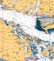
Obviously this is just a start - it uses an advanced bit of code I created as an enhancement from the module that plots the vessel tracking here on the mate. It has been enhanced to provide for base maps that cover less then the entire earthīs surface and can autmoatically select the map with the best scale that contains the point or points to be plotted from all those available.The best part is the ability to set the lat/long on a web form by clicking on a Chart (also from the list of those available)
Put this all together and now SAR missions can have their Lat/Long selected by a click and all are then automatically plotted on a map for later analysis.
pretty cool eh!
i
You must login or register to post comments Login/Signup
| RSS feed | Feed Description |
|---|---|
| Complete RSS feed | |
| RSS feed for: Bosunīs Log | |
| A Rich Site Summary (RSS) feed is an xml data file that provides a summary of the information contained here. It is not designed to be viewed in your browser, but instead by rss reader software. If you do not know what this means - you can safely ignore it, as it is provided for advanced users with rss reader software only. | |


