July 9th, 2008
July 9th, 2008
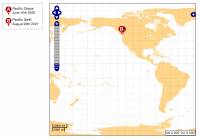
New Tracking Map Interface
I have mentioned this quite some time ago - but itīs finally online and running for the 2008 summer SALTS trips. New and Improved interface for vessel tracking that uses an advanced open-source mapping engine along with custom Chart data for coastlines around the world.Iīve probably put About 3 months solid R&D into this new interface and there is a lot more work to do, but itīs finally to a stage where I can post it here for the vessel tracking system.
To some extent I was waiting for the 2008 Offshore to return before changing anything, and not that the Summer Trips are Starting up the time was right. In the new interface you can pan and zoom all around and look in detail at the route taken. All the positions are far more accurate and the whole system should be a lot faster.
So enjoy - and Stay tuned as I have loads more to add - including a lot more in terms of usability and I hope to provide a better means of the public adding their own routes to the system.
i
You must login or register to post comments Login/Signup
| RSS feed | Feed Description |
|---|---|
| Complete RSS feed | |
| RSS feed for: Bosunīs Log | |
| A Rich Site Summary (RSS) feed is an xml data file that provides a summary of the information contained here. It is not designed to be viewed in your browser, but instead by rss reader software. If you do not know what this means - you can safely ignore it, as it is provided for advanced users with rss reader software only. | |


