

Thread #212
 by: kpbosun January 11th, 2006 |
Connected and Covered
Today I´m feeling a bit more in-tune then I have... the new system is running correctly and I have a 40´ tarp on my leaking roof... all is well (or better at least)
We had been planning a new roof for the spring - but yesterday night it started to leak - we though it would hold out the winter - I guess not. So now we have a 30´x40´ tarp afixed to the west side of our roof and are expecting several quotes to come in next week. We are still wearing smiles though - as so many other things are still going well in life... On the work side - the new computer is starting to buzz along happily - and I´m finally getting things done - which is good as I´m almost a month behind after about 2 weeks of down-time. So, today - it´s back to the Coast Guard boat for training... which is what I always recommend with things at home are falling apart and you don´t really have time for it! ;) get out that and do something completely different - which is precisely what I plan on doing!  |
Discussion:
|
by: kpbosun January 9th, 2006 |
Comments about Connected and Covered
You bet!! New stuff can be exciting. I was still a sextant navigator on my last voyage to sea, but today I tried something new. I had bought a GPS + map software package on sale a couple of weeks ago and finally got a chance to try it out. I loaded it onto a 486 -233MHz laptop, (it reccommended a P-3), plugged a converter into the cigarette lighter, fired it up and drove off. Not only did it give me constant course and speed, it showed me where I was on a map the whole time. I am still amazed. The current generation will take this for granted I guess, but I still remember being 40 miles off position approaching the east coast of Florida after two days of bad weather and Gulf Stream Swirls. Even the RDF readings weren´t much help. I went on line this afternoon looking at new laptops. The bug has bit.
Keep on making Virginia Fence, its the only way to work to windward. |
 by: sbaker January 10th, 2006 |
Comments Connected and Covered
Well, I´m proud to say (as much as we do use GPS all the time now) that I did learn my navs with a hand compass and only later progressed to Loran-C - GPS is relatively new for me as well... but as much as I use it I think that it´s always a good thing to remain a bit in awe of how cool it actually is.
PS: Did you hear that the Eurpean´s are launching a similar system called Galileo ? http://weblogs.macromedia.com/jd/archives/2005/12/eu_gps.cfm --
Fair Winds - and watch for squals from leeward Scott W. Baker |
|
by: kpbosun January 10th, 2006 |
Connected and Covered
The Galileo site was of interest. I had not heard about the project. Interesting that they should pick the same name as the Jupiter Probe of just a few years ago. Galileo did not have much to do with navigation. I can see why they would not want to name it Bowditch, but how about Prince Henry, or Captain Cook? Magellan would have had great meaning as well.
I was trained in the use of Loran A and C as well as the Decca system developed in England and used in major ports all over the world. I didn´t get a lot of use with them. Because of seniority, I would have had to drop a grade to sail on the newer ships that were so equipped. I sailed Chief Mate on C-3s and liked it very much right to the end. I did sail on a VC-2 that had both a 3 cm and a 10 cm radar with all manual controls. Now those were monsters to work with. They must have been top of the line in about 1945. Keep enjoying what you are doing, it sounds like great fun.  |
|
by: sbaker January 11th, 2006 |
Connected and Covered
I questioned the name as well - perhaps they just wanted to retain the same G.P.S. initials... ;)
Here is a little tech-meets-nav story for you though... My handheld VHF radio (which easily fits in my SAR vest radio pocket) has built in gps and charts - so if I ever go in the drink I can hit the GMDSS/DSC distress button and they know exactly where I am... It truly is amazing how much things have changed in that respect - but at the same time - we still navigate on a chart the same way we have done since the days of the first explorers... 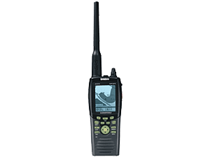 --
Fair Winds - and watch for squals from leeward Scott W. Baker |
|
by: kpbosun January 11th, 2006 |
Connected and Covered
I have a feeling that hard copy things like charts will be around for quite awhile. They are the ultimate in broad or bird´s eye views of your current situation if properly used. They are certainly not at all prone to battery drain and component failure either. It helps, of course, to know how to read them. The full time GPS crowd may lose some of that skill over time unless it is forced upon them by testing at re-certification or documentation.
Similar to your VHF hand held, my cell phone is GPS equipped as well. I could see that being an asset in any number of nasty situations, (dry situations with a cell phone most likely). When I retired, I was given a hand held GPS by some co-workers to use for hiking and RV travel. My new stuff makes it a bit redundent, but I would have to wonder about a serious hiker who goes into any sort of remote, or even not-so-remote area without one, beacon equiped of course, in pack or pocket. It´s amazing how many searches are made for people who get just a few yards off the trail and then confuse directions or twist an ankle. I finally got my son and his friends to buy small craft chart sets for their boats to back up the electronic hardware that they carry. They have commercial fishing documents, but it is really a week-end hobby for them. Their goal for next year is a big shark tournament off Cape Cod. Getting ready will probably keep them excited all through the cold weather months. |
| RSS feed | Feed Description |
|---|---|
| Complete RSS feed | |
| RSS feed for: Stories | |
| A Rich Site Summary (RSS) feed is an xml data file that provides a summary of the information contained here. It is not designed to be viewed in your browser, but instead by rss reader software. If you do not know what this means - you can safely ignore it, as it is provided for advanced users with rss reader software only. | |
i
To contribute to our forums you must login. New members can register for a user account.